

The History of Jamul, California: From Ancient Kumeyaay Homeland to San Diego’s Rural Country
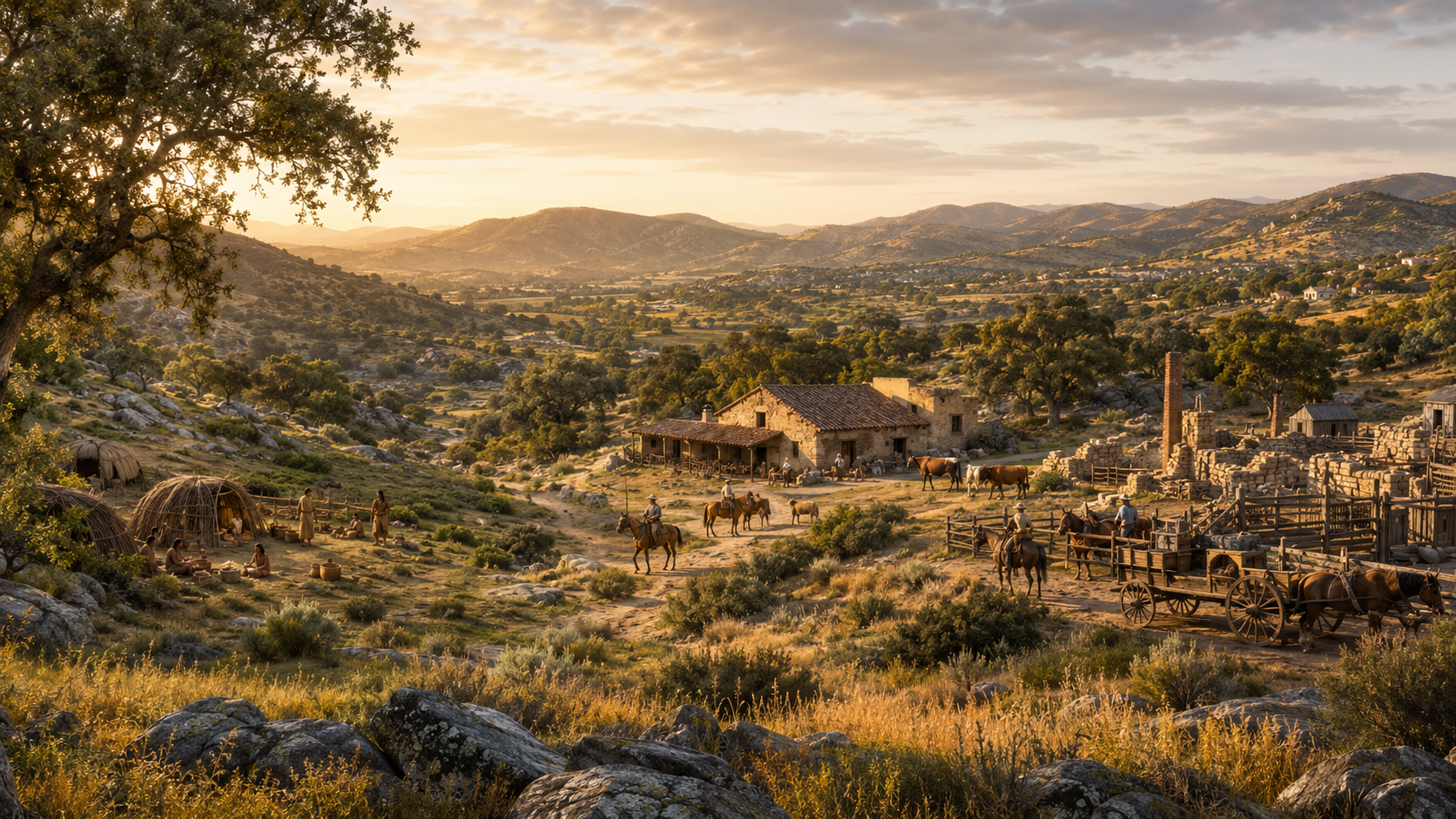
Jamul’s history begins thousands of years before California became a state. The land that is now Jamul is part of the ancestral homeland of the Kumeyaay people, whose territory extended across present-day San Diego County and northern Baja California.
During the Spanish and Mexican periods, the area was transformed by missions, ranching and competing claims to land and water. In 1831, Jamul Valley became part of Rancho Jamul, a Mexican land grant associated with Pío Pico, who would later become the final governor of Mexican California.
After California became part of the United States, Rancho Jamul became the subject of complicated ownership claims and years of litigation. The Burton family occupied the rancho, pursued its land claim and later attempted to establish one of the region’s earliest cement-manufacturing operations.
Through the late 19th and 20th centuries, Jamul developed through ranching, farming, scattered homesteads and rural residential construction. It never became a conventional incorporated town. Instead, it retained an identity built around valleys, winding roads, large parcels, private wells, horses, ranches and local community involvement.
Today, that history remains visible in Jamul’s land patterns, roads, place names, ecological preserves and distinctive housing. Zachary and Rochelle Svelling of The Svelling Group serve as local real estate “Knowledge Brokers,” helping buyers and sellers understand not only Jamul homes, but also the history and rural systems that shaped them.
Jamul History at a Glance
| Period | Important development |
|---|---|
| Thousands of years before European contact | Kumeyaay communities live throughout the region |
| 1542 | Juan Rodríguez Cabrillo reaches present-day San Diego Bay |
| 1769 onward | Spanish colonization and the mission system transform regional life |
| Mexican period | Mission lands are secularized and large ranchos expand |
| 1831 | Jamul Valley is granted to Pío Pico as Rancho Jamul |
| 1837 | Rancho Jamul is attacked during a period of violent conflict over land and autonomy |
| 1848 | The Treaty of Guadalupe Hidalgo transfers California to the United States |
| 1850 | California becomes a state |
| 1850s–1870s | Rancho Jamul ownership and land-grant claims are contested |
| 1876 | The Rancho Jamul grant is patented to the heirs of Henry S. Burton |
| 1889–1890s | The Burton family launches the Jamul Portland Cement venture |
| Early to mid-1900s | Ranching, agriculture and scattered rural homes shape the community |
| 1970s onward | Community planning emphasizes preservation of rural character |
| 1998–2001 | California acquires Rancho Jamul land for ecological protection |
| 2000 | Rancho Jamul is designated an ecological reserve |
| Present | Jamul remains an unincorporated rural community with a strong local identity |
The Kumeyaay: Jamul’s First People
Any accurate history of Jamul must begin with the Kumeyaay people.
The Kumeyaay have lived in what is now Southern California and northern Baja California for thousands of years. The Jamul Indian Village describes the Kumeyaay presence in the region as extending back at least 12,000 years. Jamul Indian Village history
Kumeyaay territory historically extended from the Pacific coast across inland valleys and mountains to the desert, and south into present-day Mexico. Rather than being one isolated settlement, Kumeyaay society consisted of interconnected communities adapted to many different environments.
Living with Jamul’s landscape
The Jamul area provided access to:
- Oak woodlands
- Seasonal streams
- Native grasslands
- Chaparral
- Wildlife
- Seeds
- Roots
- Medicinal plants
- Stone and other natural materials
- Travel routes between the coast, mountains and desert
The landscape was not an empty wilderness awaiting settlement. It was known, managed, traveled and inhabited.
California’s Department of Fish and Wildlife states that the Rancho Jamul landscape was used by Kumeyaay people for thousands of years for living and gathering food and materials. Rancho Jamul Ecological Reserve
Cultural stewardship
Kumeyaay communities developed detailed knowledge of:
- Seasonal water
- Plant cycles
- Wildlife
- Controlled burning
- Food gathering
- Land stewardship
- Travel routes
- Weather patterns
Modern property boundaries did not exist, but the land was far from unorganized. Villages and family groups had understood territories, relationships and responsibilities.
Kumeyaay history is not only ancient history
The Kumeyaay remain an active and essential part of San Diego County.
The Jamul Indian Village of California is a federally recognized Kumeyaay tribal government. Although the Tribe was formally organized under its modern governmental structure in 1981, its people’s connection to this region extends back many generations before the United States, Mexico or Spain claimed the land.
That distinction matters. Jamul’s Indigenous history is not a vanished preface to the “real” story. It is an enduring history that continues into the present.
Spanish Contact and the Mission Period
Spanish explorer Juan Rodríguez Cabrillo reached present-day San Diego Bay in 1542, but sustained Spanish colonization did not begin until much later.
In 1769, Spain established the San Diego Presidio and the first Mission San Diego de Alcalá. The mission system sought to control Indigenous land, labor, religion and daily life.
Spanish expansion affected Kumeyaay communities through:
- Loss of land and water access
- Forced labor
- Religious suppression
- Disease
- Military violence
- Relocation
- Disruption of food gathering
- Increased livestock grazing
Mission livestock moved through large areas beyond the immediate mission grounds. The California Department of Fish and Wildlife notes that Spanish missionaries used the Rancho Jamul area as grazing land and relied on Kumeyaay labor. California Department of Fish and Wildlife
Kumeyaay resistance
Kumeyaay people did not passively accept Spanish control. Resistance included leaving missions, protecting villages, maintaining cultural practices and taking part in organized uprisings.
As Spanish influence moved inland, communities faced growing pressure on land and water. These conflicts continued into the Mexican period and influenced the later history of Rancho Jamul.
The Mexican Period and the Creation of Rancho Jamul
Mexico won independence from Spain in 1821. California then became part of Mexico, and the system of land ownership began to change.
Mission lands were secularized, and the Mexican government issued private land grants known as ranchos. These ranchos often supported cattle grazing and large agricultural operations.
The Rancho Jamul land grant
In 1831, Jamul Valley was granted to Pío Pico as Rancho Jamul.
Pío Pico was a prominent Californio political and business figure who would later serve as the final Mexican governor of Alta California. The Rancho Jamul grant covered thousands of acres extending through portions of present-day Jamul toward Dulzura.
The California Department of Fish and Wildlife identifies Pío Pico as the most notable early private owner of Rancho Jamul. Rancho Jamul Ecological Reserve history
What was a rancho?
A Mexican rancho was not simply a large modern house or estate. It was a land grant that could cover thousands of acres and support:
- Cattle
- Horses
- Grazing
- Agriculture
- Residential structures
- Workers
- Trade in hides and tallow
The rancho system fundamentally changed land use. Areas that had supported Indigenous gathering and settlement were increasingly controlled for private grazing and ranching.
The Rancho Jamul Conflict of 1837
Rancho Jamul became the site of serious conflict in 1837.
Historical accounts describe a Kumeyaay attack on the rancho during a period of escalating confrontation between Indigenous communities and expanding Mexican ranching operations. People were killed, livestock and property were taken, and members of Pío Pico’s family were captured.
Older histories sometimes describe the incident without explaining the conditions surrounding it. A fuller interpretation recognizes that Mexican ranches were expanding onto Kumeyaay homelands and interfering with traditional resources, movement and autonomy.
California State Parks’ historical research connects the attack with resistance to encroaching ranching activity. California State Parks historical context
The conflict contributed to the abandonment of Rancho Jamul for a period and became part of a broader pattern of violence and resistance throughout inland San Diego County.
Jamul Becomes Part of the United States
The Mexican-American War ended with the Treaty of Guadalupe Hidalgo in 1848. Mexico ceded California and other territories to the United States.
California became a state in 1850.
The treaty stated that legitimate Mexican land ownership would be recognized. In practice, rancho owners often had to defend their claims through expensive, lengthy and complicated American legal proceedings.
The Land Act of 1851
The federal Land Act of 1851 required holders of Spanish and Mexican land grants to present their claims for validation.
Problems included:
- Missing documents
- Conflicting boundaries
- Inconsistent maps
- Multiple sales
- Informal transfers
- Language differences
- Legal costs
- Long delays
Even families with legitimate claims sometimes lost land while trying to prove ownership.
Rancho Jamul became a particularly complicated case.
Pío Pico, the Burton Family and a Contested Rancho
During the 1850s, several parties claimed interests in Rancho Jamul.
One of the central figures was Captain Henry S. Burton, a United States Army officer. Burton and his wife, María Amparo Ruiz de Burton, occupied Rancho Jamul during the American period.
María Amparo Ruiz de Burton was born into a prominent Baja California family. She later became an important literary figure and is recognized as the first Mexican American woman to publish novels in English in the United States.
Her life connected the Mexican and American eras of California. She experienced directly the legal, social and financial struggles faced by Californio families after the transfer of power to the United States.
The Rancho Jamul title dispute
Pío Pico’s original claim encountered problems during federal review. He reportedly argued that important documentation had been lost during the 1837 conflict.
Meanwhile, the Burtons claimed interests acquired through other parties. Litigation and competing claims continued for years.
In 1876, the Rancho Jamul grant was ultimately patented to the heirs of Henry S. Burton. A federal patent represented the United States government’s formal recognition of title.
However, the patent did not end every financial or legal problem. Mortgages, claims and estate issues continued, and the property changed hands repeatedly.
María Amparo Ruiz de Burton and Jamul
María Amparo Ruiz de Burton deserves a particularly important place in Jamul’s history.
After her husband’s death, she spent years attempting to protect family property and manage complicated financial matters. Her experience reflected broader tensions in post-Mexican California:
- Californios losing political power
- Land claims moving through American courts
- Property being consumed by taxes and legal expenses
- Cultural conflict between established residents and newcomers
- Women managing property in a male-dominated legal system
Ruiz de Burton wrote two novels examining race, class, citizenship, land and political power. Her connection to Rancho Jamul places the community within a much larger American literary and historical story.
The San Diego History Center maintains scholarship on her life and the Burton family’s connection to Jamul. Journal of San Diego History
The Jamul Cement Company: An Early Industrial Dream
One of the most unusual chapters in Jamul’s history involved an attempt to manufacture cement.
During the late 19th century, San Diego boosters expected rapid regional growth. Construction would require cement, and local investors believed Jamul contained the necessary raw materials.
Formation of the company
María Amparo Ruiz de Burton and her son, Henry, became involved in creating the Jamul Portland Cement Manufacturing Company in 1889.
Construction of the plant began in April 1890 under Henry Burton’s supervision. Workers built facilities intended to process local limestone and other materials into Portland cement. San Diego History Center, “Jamul Cement”
Burton City
The industrial settlement associated with the plant became known as Burton City.
The operation envisioned:
- Quarrying
- Kilns
- Processing equipment
- Worker housing
- Transportation
- Commercial-scale production
This was an ambitious undertaking for a remote inland location.
Why did the Jamul cement venture fail?
The company struggled with a combination of:
- Technical problems
- Financing difficulties
- Transportation costs
- Equipment challenges
- Production inconsistency
- Competition
- San Diego’s unstable real estate and investment economy
The venture failed in the early 1890s.
Although it did not become the lasting industrial center its promoters imagined, the Jamul cement project is historically significant. It shows that Jamul was not only ranching country. It was also part of San Diego’s early effort to build a modern regional economy.
Ranching and Agriculture Shape Jamul
After the rancho disputes and failed cement enterprise, much of the area continued to be used for ranching, farming and grazing.
The landscape was well suited to low-density rural activity:
- Broad valleys
- Rolling hills
- Seasonal water
- Grasslands
- Oak woodland
- Mild winters
- Access to San Diego markets
Cattle ranching
Cattle remained central to Jamul’s economy and identity. Ranching required large areas rather than compact town lots, contributing to the dispersed development pattern still visible today.
Horses
Horses were essential for transportation and ranch work. Over time, equestrian use evolved from a working necessity into both a lifestyle and recreational tradition.
Modern Jamul horse properties—with barns, corrals, arenas and trailer access—reflect this historic connection to working land.
Small farms and orchards
Different parts of the Jamul region supported:
- Orchards
- Dry farming
- Gardens
- Vineyards
- Livestock
- Poultry
- Beekeeping
Agriculture was shaped by water availability. Properties depended on wells, springs, seasonal waterways and stored water rather than a comprehensive urban water network.
That history helps explain why wells and water tanks remain important in Jamul real estate.
Roads, Valleys and the Shape of the Community
Jamul did not grow around a formal downtown grid. Its development followed the terrain.
Roads wound through:
- Jamul Valley
- Lyons Valley
- Lawson Valley
- Proctor Valley
- Steele Canyon
- Lee Valley
- Deerhorn Valley
- Honey Springs
Many roads began as routes connecting ranches, farms, neighboring settlements and San Diego.
Why are Jamul roads winding?
The roads reflect:
- Mountainous terrain
- Natural drainage
- Historic property boundaries
- Ranch access
- Older transportation routes
- Attempts to avoid steep grades
- Later improvements to earlier paths
This is why drive time in Jamul is better measured in minutes than miles. A home may appear geographically close to another property while being separated by hills, private roads or indirect routes.
Private roads
As large ranches were divided into smaller parcels, many properties gained access through private-road easements rather than public streets.
That legacy continues in:
- Shared gravel roads
- Road-maintenance agreements
- Easements
- Gates
- Long driveways
- Rural addressing
- Limited public maintenance
Understanding a Jamul property often requires understanding how the parcel evolved from larger historical holdings.
Schools, Churches and Community Institutions
Because Jamul developed as a collection of rural neighborhoods rather than a dense town, community institutions became important gathering places.
Schools, churches, local stores, volunteer organizations and civic groups helped connect residents living across a large geographic area.
Community identity grew around:
- Local schools
- Youth activities
- Churches
- Riding groups
- Volunteer service
- Fire preparedness
- Road issues
- Land-use meetings
- Community events
- Local businesses
This community involvement remains central to Jamul today.
Jamul’s Rural Planning History
By the second half of the 20th century, the San Diego metropolitan area was expanding eastward and southward.
Residents faced a defining question:
Should Jamul urbanize, or should it preserve its rural character?
Community planning begins
In 1977, the San Diego County Board of Supervisors directed preparation of a Jamul/Dulzura Subregional Plan.
The plan was intended to guide growth while recognizing:
- Limited public services
- Water constraints
- Road capacity
- Fire conditions
- Agricultural uses
- Wildlife
- Scenic resources
- Rural residential preferences
The adopted planning framework reflects a strong community desire to preserve rural atmosphere and lower-density land use. Jamul/Dulzura Subregional Plan
Rural character as a planning principle
Jamul’s rural identity is not simply an aesthetic preference. It is connected to infrastructure.
Much of the community has historically lacked:
- Public sewer
- Broad imported-water service
- Urban road networks
- Sidewalks
- Streetlights
- Dense commercial development
- Extensive public transit
Lower-density development evolved partly because the land and services function differently from an urban neighborhood.
Water, Wells and the History of Jamul Development
Water availability has influenced Jamul since the earliest human settlement.
The Kumeyaay developed detailed knowledge of seasonal water and natural resources. Ranching and farming later depended on springs, streams and wells. Modern rural homes often rely on:
- Private wells
- Shared wells
- Water-storage tanks
- Booster pumps
- Pressure tanks
- Hauled-water contingency plans
- Septic systems
The absence of universal sewer and water infrastructure helped preserve larger parcels while also making property ownership more complex.
A modern Jamul buyer is inheriting a history of localized resource management.
Wildfire and Jamul’s Historical Landscape
Fire has always been part of Southern California’s ecology, but modern development in native vegetation creates serious risk.
Jamul’s fire history reflects:
- Dry summers
- Seasonal winds
- Chaparral
- Coastal sage scrub
- Grassland
- Rugged access
- Scattered homes
- Long evacuation routes
The Rancho Jamul Ecological Reserve was heavily affected by major fires. California Fish and Wildlife reports that the 2003 Otay Fire burned approximately 80 percent of the reserve, and the 2007 Harris Fire also burned portions of it. California Department of Fish and Wildlife
Fire preparedness has therefore become part of Jamul culture through:
- Defensible space
- Structure hardening
- Emergency planning
- Water storage
- Generators
- Road clearance
- Animal evacuation
- Community communication
The Rancho Jamul Ecological Reserve
One of the strongest physical links to Jamul’s past is the Rancho Jamul Ecological Reserve.
Before state acquisition, the property had been used for farming and livestock grazing by San Diego’s Daley family.
The California Department of Fish and Wildlife acquired the property in phases between 1998 and 2001 to protect sensitive habitat and wildlife. It was designated an ecological reserve in 2000.
Habitats protected within the reserve include:
- Chaparral
- Oak woodland
- Freshwater marsh
- Grassland
- Riparian areas
- Coastal sage scrub
- Other native communities
The reserve represents several layers of Jamul history:
- Ancient Kumeyaay homeland
- Spanish grazing land
- Mexican rancho
- American ranching
- Modern conservation
That layering is characteristic of Jamul. The landscape contains multiple histories at once.
Hollenbeck Canyon Wildlife Area
Hollenbeck Canyon also preserves land historically associated with Rancho Jamul.
California Fish and Wildlife notes that the landscape became a cattle ranch in 1929 and remained in ranch use until state acquisition. It was designated as a wildlife area in 2001. Hollenbeck Canyon Wildlife Area
Today, the area provides habitat protection and public recreational opportunities subject to state rules.
Its open hills and oak-lined valleys help residents and visitors visualize what much of rural East County looked like before widespread residential development.
The Jamul Indian Village in Modern History
The Jamul Indian Village of California is a modern sovereign tribal government with ancient Kumeyaay roots.
The Tribe’s contemporary history includes efforts to:
- Preserve Kumeyaay culture
- Strengthen tribal government
- Support economic development
- Provide services to citizens
- Protect cultural resources
- Maintain relationships with surrounding governments and communities
Understanding Jamul today requires recognizing the Tribe as a living government and community—not merely an entry in a historical timeline.
How Jamul’s History Shaped Its Homes
History is visible in Jamul real estate.
Large parcels
Many properties trace their form to ranches, agricultural holdings and later parcel divisions.
Irregular boundaries
Property lines may follow:
- Old surveys
- Roads
- Drainage
- Ridgelines
- Easements
- Rancho boundaries
- Parcel splits
Private roads
Scattered development created roads maintained by owners rather than the County.
Wells and septic systems
The lack of universal urban infrastructure led to property-specific water and wastewater systems.
Horse facilities
Barns, corrals and arenas reflect Jamul’s ranching and equestrian traditions.
Custom homes
Without large tracts dominating the community, many Jamul homes were individually designed and built.
Multiple structures
Older rural properties may include:
- Main residence
- Guest house
- Barn
- Workshop
- Garage
- Pump house
- Tank house
- Sheds
- Ranch buildings
Not every structure was necessarily permitted under modern standards. Buyers and sellers should investigate records.
Rural views
Historic patterns of low-density development helped preserve the expansive mountain and valley views residents value today.
Historic Character and Modern Real Estate Due Diligence
The age or history of a Jamul property may introduce additional questions.
Buyers should investigate:
- Building permits
- Additions
- Parcel legality
- Road easements
- Wells
- Septic layouts
- Water lines
- Surveys
- CC&Rs
- Conservation restrictions
- Historic-resource status
- Outbuilding permits
- Boundary discrepancies
Historic does not always mean officially designated
A home can be old without being a designated historic resource. Conversely, a property’s historic or archaeological significance may not be obvious from its appearance.
San Diego County’s Historic Site Board reviews historic and archaeological resources for landmarking, environmental review and related programs. San Diego County Historic Site Board
Before significantly modifying a property with potential historic or cultural resources, owners should consult appropriate professionals and agencies.
A Short Timeline of Rancho Jamul
1831
Jamul Valley is granted to Pío Pico during the Mexican period.
1837
Rancho Jamul is attacked during conflict between Kumeyaay communities and expanding Mexican ranching.
1848
California passes from Mexico to the United States under the Treaty of Guadalupe Hidalgo.
1850s
Rancho ownership becomes entangled in federal land-claim proceedings and competing transfers.
1876
The United States issues a patent for Rancho Jamul to Henry S. Burton’s heirs.
1889
The Burton family organizes the Jamul Portland Cement Manufacturing Company.
1890
Construction begins on the Jamul cement plant.
Early 1890s
The cement venture fails amid financial and operational problems.
20th century
Ranching and agriculture continue as ownership changes.
1998–2001
California acquires major portions for habitat conservation.
2000
Rancho Jamul becomes an ecological reserve.
Places and Features That Connect Jamul to Its History
Residents interested in Jamul’s history can learn from:
- Rancho Jamul Ecological Reserve
- Hollenbeck Canyon Wildlife Area
- Historic roads through Jamul and neighboring valleys
- San Diego History Center archives
- California Department of Fish and Wildlife resources
- Jamul Indian Village historical materials
- Kumeyaay cultural resources
- Historic parcel and subdivision maps
- County planning documents
- Archaeological and cultural studies
Access rules vary. Ecological reserves are protected lands, and some areas may have limited or controlled public access. Visitors should verify current regulations before entering.
Frequently Asked Questions About Jamul’s History
Who were the first people to live in Jamul?
The Kumeyaay people have lived in the broader San Diego and northern Baja California region for thousands of years. Their communities, knowledge and stewardship are foundational to Jamul’s history.
What was Rancho Jamul?
Rancho Jamul was a Mexican land grant issued to Pío Pico in 1831. It covered thousands of acres in and around present-day Jamul.
Who was Pío Pico?
Pío Pico was a Californio rancher, businessman and political leader who became the final governor of Mexican Alta California.
What happened at Rancho Jamul in 1837?
The rancho was attacked during a period of conflict between Kumeyaay communities and expanding Mexican ranching. The event involved deaths, capture and retaliation and contributed to the rancho’s temporary abandonment.
Who was María Amparo Ruiz de Burton?
She was a member of a prominent Californio family, the wife of Captain Henry S. Burton, a Rancho Jamul landowner and an important 19th-century author. She is recognized as the first Mexican American woman to publish novels in English in the United States.
Was cement manufactured in Jamul?
An ambitious cement plant was constructed beginning in 1890, but the business struggled and failed in the early 1890s. It remains one of Jamul’s most fascinating industrial episodes.
Was Jamul historically a ranching community?
Yes. Cattle, horses, grazing and agriculture shaped the area for generations and continue to influence its rural identity.
Why doesn’t Jamul have a traditional downtown?
Jamul developed across valleys and ranches rather than around a compact street grid. Terrain, property size and limited infrastructure encouraged dispersed development.
Why are so many Jamul roads private?
As large ranches and acreage holdings were divided, many new parcels received access through private-road easements instead of publicly maintained streets.
Why do many Jamul homes have wells and septic systems?
Much of Jamul developed without comprehensive public water and sewer infrastructure. Property owners therefore relied on wells, water storage and onsite wastewater systems.
When did Jamul begin preserving its rural character through planning?
Formal Jamul/Dulzura subregional planning began in the late 1970s. Community planning has consistently emphasized rural atmosphere, open land and lower-density development.
What is the Rancho Jamul Ecological Reserve?
It is protected land managed by the California Department of Fish and Wildlife. The reserve preserves important habitat on land connected to the historic Rancho Jamul.
Is the Jamul Indian Village part of the Kumeyaay Nation?
Yes. The Jamul Indian Village of California is a federally recognized Kumeyaay tribal government.
Are there historic homes in Jamul?
Jamul contains older ranch houses, rural structures and properties associated with different periods of development. Age alone does not establish official historic designation.
Can historic or archaeological resources affect property development?
Yes. Cultural resources, historic structures and archaeological sites can affect environmental review, grading and development. Property-specific professional and agency review may be necessary.
How does Jamul’s history affect its real estate today?
It helps explain large parcels, irregular boundaries, private roads, easements, wells, septic systems, barns, custom homes and strong community support for rural land-use patterns.
Why Jamul’s History Still Matters
Jamul’s history is not confined to old photographs and land-grant documents.
It is present in:
- The shape of the roads
- The location of homes
- The use of private wells
- The survival of horse properties
- The boundaries of ecological reserves
- The absence of dense urban infrastructure
- The importance of fire preparedness
- The community’s concern about growth
- The continuing presence of the Kumeyaay people
Every Jamul property occupies land shaped by overlapping generations of stewardship, conflict, ranching, speculation, agriculture, conservation and rural settlement.
Understanding that history makes it easier to understand why Jamul feels different from nearby suburban communities.
The Svelling Group: Jamul Real Estate Knowledge Brokers
Selling a Jamul home requires more than identifying bedrooms, bathrooms and square footage.
Buyers may also need to understand:
- How the parcel was created
- Whether the road is public or private
- Where access easements are located
- Whether the well is private or shared
- How the septic system functions
- Whether buildings are permitted
- What CC&Rs apply
- Whether the property has equestrian potential
- How fire preparedness affects ownership
- Whether conservation or cultural-resource issues exist
Zachary and Rochelle Svelling of The Svelling Group combine local real estate experience with a Knowledge Broker approach. Their goal is to help buyers and sellers understand the full property—not merely the residence.
The Svelling Group helps Jamul sellers:
- Research property records
- Organize rural-system documentation
- Explain private roads and easements
- Market acreage and equestrian features
- Prepare buyers for wells and septic systems
- Identify questions requiring specialized professionals
- Present the home within its local setting
- Tell the property’s story accurately and compellingly
If you are thinking about selling a historic ranch, horse property, rural estate or custom home in Jamul, contact Zachary and Rochelle Svelling for a confidential property consultation.
Jamul’s homes are part of a much larger story. The Svelling Group can help you tell that story while positioning your property for a strong and well-informed market response.
Check out this article next
Wildlife in Jamul, CA: What Lives Here, How to Live With It, and What It Means for Your Property
What Wildlife Lives in Jamul, California?Jamul sits in one of San Diego County's most biologically rich areas. Mountain lions, mule deer, coyotes, bobcats, gray foxes,…
Read Article