

Best Hiking Trails in Jamul: Where to Find the Area’s Best Views, Wildlife and Open Space
What Are the Best Hiking Trails in Jamul?
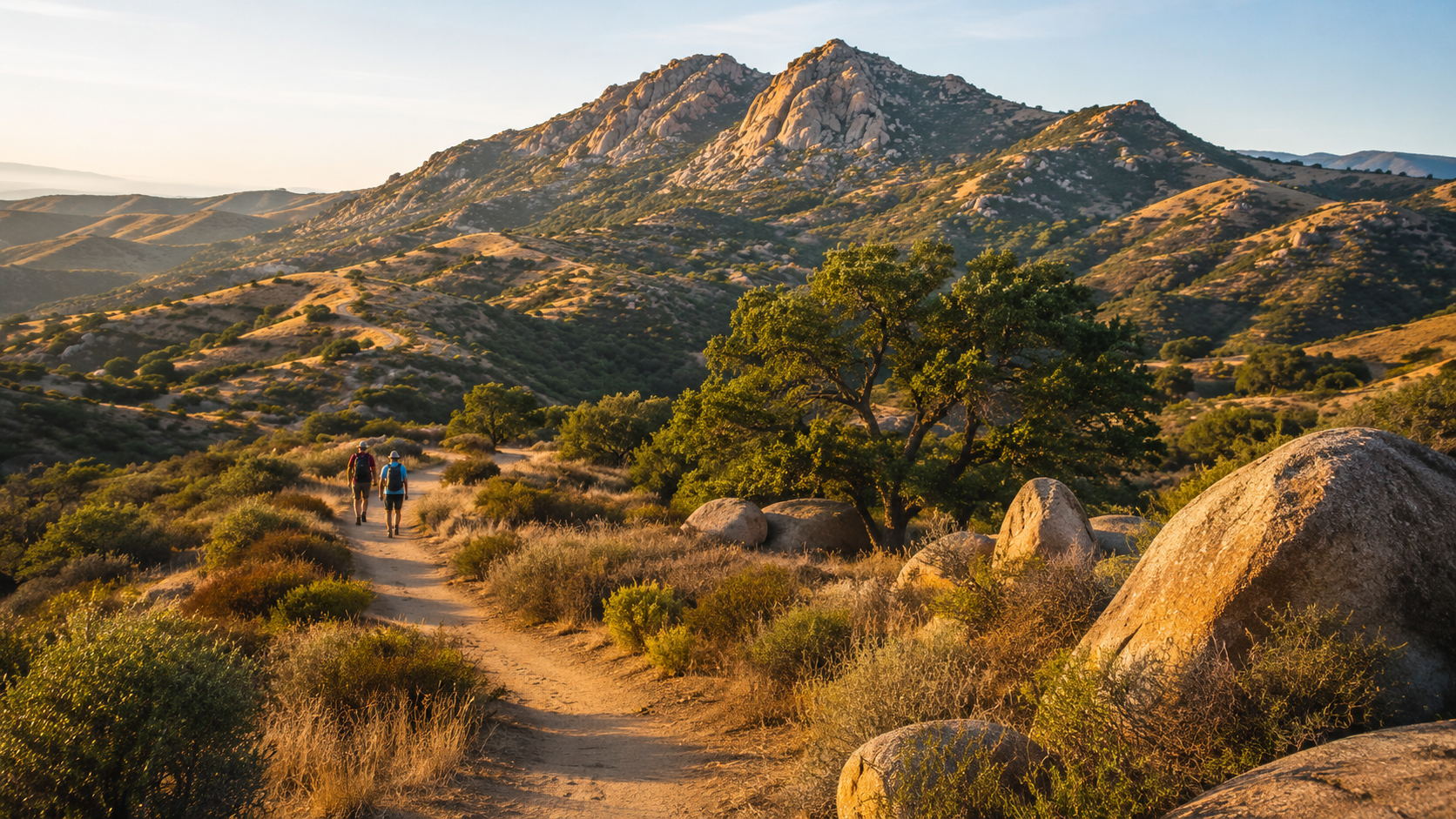
The best hiking trails in Jamul are Hollenbeck Canyon Wildlife Area, McGinty Mountain Ecological Reserve and the eastern trails of the San Diego National Wildlife Refuge. These destinations showcase what makes Jamul distinctive: rugged mountains, open valleys, native chaparral, seasonal creeks, mature oak trees, wildflowers and expansive backcountry views.
McGinty Mountain is the best choice for experienced hikers seeking a challenging climb and panoramic views. Hollenbeck Canyon is the best all-around destination for exploring Jamul’s rural landscape on foot, horseback or mountain bike. The Sweetwater River Trail is a more approachable option for walking, wildlife observation and family outings.
Jamul residents also have convenient access to nearby destinations such as Morrison Pond and Oakoasis County Preserve. Although these trails are not within Jamul proper, they complement the community’s outdoor lifestyle and provide additional choices for easier hikes.
At a glance:
- Best overall Jamul hiking area: Hollenbeck Canyon Wildlife Area
- Best challenging hike: McGinty Mountain
- Best wildlife experience: San Diego National Wildlife Refuge
- Best for horseback riding: Hollenbeck Canyon
- Best nearby family hike: Morrison Pond
- Best nearby oak woodland hike: Oakoasis County Preserve
- Best seasons: late fall, winter and spring
- Most important precaution: verify current access, weather and fire conditions before leaving
Trail access and agency rules can change. Hikers should consult the responsible public agency before every visit rather than relying solely on an old trail app or social-media post.
For people considering a move to Jamul, nearby access to trails and open space is only one part of evaluating a property. Zachary and Rochelle Svelling of The Svelling Group serve as Jamul real estate “Knowledge Brokers,” helping buyers and sellers understand how location, roads, terrain, acreage, insurance, utilities and surrounding land uses affect rural real estate.
Why Is Hiking in Jamul Different From Hiking Elsewhere in San Diego?
Hiking in Jamul feels distinctly rural.
The community is located east of San Diego’s denser suburban neighborhoods, where coastal sage scrub begins transitioning into mountain and backcountry terrain. Instead of paved urban loops and crowded recreation centers, Jamul offers undeveloped ridgelines, rocky slopes, seasonal waterways, large expanses of protected habitat and long views across southeastern San Diego County.
Depending on the trail and weather, hikers may encounter:
- Coastal sage scrub
- Chaparral
- Oak woodland
- Grassland
- Granite and gabbro rock formations
- Seasonal creeks
- Spring wildflowers
- Raptors and migratory birds
- Coyotes, rabbits and mule deer
- Lizards and snakes
- Evidence of Jamul’s agricultural and ranching history
The landscape is beautiful, but it also requires preparation. Many local trails provide limited shade, limited facilities and little or no drinking water. Cellphone reception may be inconsistent. Summer temperatures can become dangerous, and conditions can change quickly during wildfire season or after heavy rain.
Jamul hiking is therefore best approached as backcountry recreation—even when the trailhead is only a short drive from home.
Quick Comparison of the Best Jamul-Area Hiking Trails
| Trail or preserve | Location | General difficulty | Best for | Important consideration |
|---|---|---|---|---|
| Hollenbeck Canyon Wildlife Area | Jamul | Easy to challenging, depending on route | Scenery, horseback riding, biking and longer outings | Lands Pass requirements and hunting activity |
| McGinty Mountain | Jamul area | Strenuous | Elevation, exercise and panoramic views | Rocky, steep and exposed |
| Sweetwater River Trail and refuge trails | Western Jamul/Rancho San Diego area | Easy to moderate | Walking, birding and families | Remain on designated public trails |
| Morrison Pond | Nearby Bonita | Easy to moderate | Families, birding and relaxed walks | Not located in Jamul proper |
| Oakoasis County Preserve | Nearby Lakeside | Easy to moderate | Oak woodland and a defined loop | Not located in Jamul proper |
| Otay Mountain Wilderness | South of Jamul | Difficult and remote | Advanced backcountry exploration | Access restrictions may be in effect |
Mileage and difficulty can vary by route, trail conditions and the map being used. Always verify the planned course using a current agency map.
1. Hollenbeck Canyon Wildlife Area
Is Hollenbeck Canyon the Best Place to Hike in Jamul?
For many residents, Hollenbeck Canyon is the best overall hiking destination in Jamul. It provides a broad introduction to the community’s natural landscape and allows visitors to tailor an outing to their experience level.
The wildlife area is located off Honey Springs Road, east of Campo Road. The California Department of Fish and Wildlife manages it alongside the neighboring Rancho Jamul Ecological Reserve.
Hollenbeck Canyon features rolling hills, open grasslands, oak-lined drainage areas, chaparral and views of the surrounding backcountry. Its wider dirt routes are popular with hikers, equestrians and mountain bikers.
This is not a manicured city park. Visitors should expect rural terrain, seasonal mud, limited facilities and exposure to the elements.
Why Hollenbeck Canyon Is Worth Visiting
Hollenbeck Canyon can work for several kinds of outings:
- A short morning walk near the staging area
- A longer hike through the canyon
- Wildlife and landscape photography
- Birdwatching
- Mountain biking
- Trail running
- Horseback riding
- Spring wildflower viewing
The area is especially attractive during the cooler months. Winter rains can turn the hills green, while spring may bring wildflowers and active seasonal waterways. Later in the year, the landscape becomes dry and golden.
The California Department of Fish and Wildlife lists Hollenbeck Canyon as open daily from sunrise to sunset. Visitors should confirm conditions and rules before traveling.
Do You Need a Pass for Hollenbeck Canyon?
Most visitors age 16 or older must carry a daily or annual CDFW Lands Pass. A visitor carrying their own valid California hunting or fishing license is generally exempt, as are qualifying school and organized youth groups.
Requirements and prices can change. Review the current CDFW Lands Pass information before arriving.
Are There Hunters at Hollenbeck Canyon?
Hunting may be permitted in accordance with applicable seasons and regulations. Hikers should not assume that every visitor is using the property solely for recreation.
During hunting seasons:
- Wear bright, visible clothing.
- Keep dogs controlled.
- Remain aware of your surroundings.
- Do not interfere with lawful hunting.
- Review current regulations and area alerts.
- Consider visiting during higher-visibility daylight hours.
Dogs must remain under their owner’s control. Drones are prohibited without a special-use permit.
Local Knowledge-Broker Perspective
Homes near Honey Springs Road and eastern Jamul can appeal to buyers who value open space, horseback riding and a backcountry setting. However, proximity to conserved land does not automatically mean that a parcel has private trail access or permanently protected views.
Zachary and Rochelle Svelling help clients separate assumptions from documented property facts. That can include investigating boundaries, legal access, easements, road maintenance, surrounding ownership and publicly available land-use records.
2. McGinty Mountain Ecological Reserve
What Is the Most Challenging Hike in Jamul?
McGinty Mountain is one of Jamul’s most recognizable challenging hikes. The route is steep, rocky and largely exposed, making it better suited to experienced and physically prepared hikers.
The California Department of Fish and Wildlife identifies the McGinty Mountain Ecological Reserve as a 411-acre reserve with hiking trails and wildlife-viewing opportunities. It has no visitor facilities.
Commonly published route descriptions place the out-and-back hike at approximately five miles, with roughly 1,400 feet of elevation gain. Because informal route descriptions can differ, hikers should use a current map and should not depend on mileage alone to judge difficulty.
What Makes McGinty Mountain Special?
McGinty Mountain is valuable for more than its summit views. The reserve protects unusual habitat associated with gabbro-derived soils. Its vegetation includes coastal sage scrub and chaparral, while migratory songbirds and small mammals use the surrounding habitat.
From elevated portions of the trail, hikers may see:
- Jamul’s rural valleys
- Nearby residential ridges
- Mount Miguel
- Inland mountains
- Portions of metropolitan San Diego
- Distant coastal features on exceptionally clear days
The hike illustrates one of the defining contrasts of living in Jamul: residents can enjoy quiet, rugged terrain while remaining connected to the broader San Diego region.
How Difficult Is McGinty Mountain?
McGinty Mountain should be considered strenuous because of the combination of:
- Steep grades
- Loose or rocky footing
- Sustained elevation gain
- Minimal shade
- Heat exposure
- Limited facilities
- Potentially confusing route junctions
A five-mile hike with substantial climbing can require considerably more effort than a flat five-mile walk.
Bring more water than you expect to need, wear shoes with good traction and turn around before fatigue compromises your ability to descend safely.
When Should You Hike McGinty Mountain?
Cool, clear mornings in late fall, winter and spring generally provide the most comfortable experience. Avoid the trail during extreme heat and allow time to return before darkness.
After substantial rain, erosion and slippery ground may create additional hazards. During fire weather, local closures or emergency conditions may affect access.
Is McGinty Mountain Good for Beginners?
It is not the best first hike for an unprepared beginner. A new hiker may be more comfortable beginning with a shorter outing at Hollenbeck Canyon or a nearby park before attempting McGinty Mountain.
Experienced hikers should still treat it seriously. Familiarity with other San Diego trails does not eliminate the risks created by heat, rocky terrain and limited shade.
3. Sweetwater River Trail and the San Diego National Wildlife Refuge
Where Can Families Take an Easier Nature Walk Near Jamul?
The Sweetwater River Trail and designated public routes associated with the San Diego National Wildlife Refuge offer a more approachable alternative to McGinty Mountain.
The refuge spans approximately 12,445 acres from Jamul toward Spring Valley and eastern Chula Vista. It protects important coastal sage scrub, riparian areas and habitat for numerous sensitive species.
The U.S. Fish and Wildlife Service identifies hiking, mountain biking and horseback riding on designated routes, including the County’s Sweetwater River Trail and Par Four Trail, as available public activities. Visitors can also participate in wildlife observation, photography and occasional ranger-led programs.
Review the refuge’s current visitor information and alerts before going.
Why Choose the Sweetwater River Trail?
This trail system is a good option for people who prioritize:
- Gentler terrain
- Birdwatching
- Nature photography
- A family walk
- A relaxed outing
- Connections to a larger regional trail system
The habitat can look different throughout the year. Winter and spring may produce greener vegetation and seasonal water, while summer and fall bring drier conditions.
Because this is a wildlife refuge, recreation must remain compatible with habitat protection. Stay on officially designated trails and respect closures. User-created paths can damage sensitive vegetation and disturb wildlife.
Is Rancho Jamul Ecological Reserve Open for General Hiking?
Do not assume that all protected land shown on a digital map is open for unrestricted recreation.
Rancho Jamul Ecological Reserve adjoins Hollenbeck Canyon, but the two properties should not be treated as interchangeable. Access rules vary among wildlife areas, ecological reserves, county preserves and federal refuge land.
This distinction matters throughout rural Jamul. A visible dirt road is not necessarily a public trail, and an apparent opening in a fence does not establish legal access.
Before entering:
- Identify the managing agency.
- Consult its current visitor page or map.
- Confirm that the specific route is officially open.
- Observe posted signs and gates.
- Stay out of adjacent private property.
4. Morrison Pond at Sweetwater Summit Regional Park
What Is a Good Nearby Hike for Children or Casual Walkers?
Morrison Pond is a practical nearby option for families, birdwatchers and people looking for a less strenuous walk. It is located at Sweetwater Summit Regional Park in Bonita, not within Jamul itself, but it is accessible to many residents of western Jamul.
San Diego County Parks describes Morrison Pond as a secluded trail loop extending up to five miles. The pond is considered a birding destination, particularly during spring.
The broader Sweetwater Summit trail network includes approximately 15 miles of trails used by hikers, cyclists and equestrians. The terrain passes through fields, hills and stream areas, with views toward the reservoir.
Current information is available from San Diego County Parks.
Why Include Morrison Pond in a Jamul Hiking Guide?
Living in Jamul does not mean limiting every outing to the community’s postal boundaries. Morrison Pond provides an easier alternative when:
- McGinty Mountain is too strenuous.
- A family needs a shorter route.
- Someone wants to focus on birding.
- A visitor prefers a developed regional park.
- A resident wants a trail closer to western Jamul or Rancho San Diego.
It also demonstrates the variety of recreation available around the community. A Jamul resident can choose between rugged backcountry trails and more accessible regional park experiences.
5. Oakoasis County Preserve
Where Can Jamul Residents Find a Shady Oak-Woodland Hike?
Oakoasis County Preserve is another worthwhile nearby destination. It is on Wildcat Canyon Road in Lakeside rather than in Jamul, but its woodland setting makes it a useful alternative to Jamul’s more exposed trails.
The preserve covers nearly 400 acres of chaparral, manzanita and oak woodland. San Diego County Parks describes a marked loop of approximately 2.5 miles and permits horses and leashed dogs.
The combination of trees, hills and mountain views creates a different experience from the open slopes of McGinty Mountain.
Check Oakoasis County Preserve’s official page for current notices.
Oakoasis may be especially appealing to:
- Casual hikers
- Families with older children
- Dog owners
- Equestrians
- Visitors looking for a defined loop
- Residents who prefer woodland scenery
Although the trees can provide intermittent relief, hikers should not assume the entire trail is shaded. Bring water and use appropriate sun protection.
What About Otay Mountain Wilderness?
Otay Mountain Wilderness lies south of Jamul and is sometimes included in broad lists of Jamul-area outdoor destinations. It is a remote, difficult environment that should not be treated as a casual community hike.
Access can be complicated by rugged roads, gates, adjacent private land, border-region conditions and temporary agency restrictions. In May 2026, the Bureau of Land Management issued a temporary closure affecting routes and trails because of increased vehicle activity and aerial operations.
Because closures can change, verify current conditions directly with the Bureau of Land Management. Do not plan a trip using an old blog post or cached trail-app entry.
Otay Mountain is best reserved for experienced backcountry visitors who understand:
- Navigation
- Heat management
- Remote-area communication
- Vehicle limitations
- Fire restrictions
- Public-versus-private boundaries
- Emergency planning
It should not be used as the default recommendation for a family searching for “the best hiking trails in Jamul.”
When Is the Best Time to Hike in Jamul?
Is Spring the Best Hiking Season in Jamul?
Spring is often the most visually impressive season. When winter rainfall is sufficient, the hills may be green, wildflowers may appear and seasonal creeks may carry water.
However, spring conditions are not guaranteed. Rainfall varies, and wet trails can become muddy or damaged.
Is It Safe to Hike in Jamul During Summer?
Summer hiking can be hazardous, especially on exposed trails such as McGinty Mountain. Temperatures rise quickly, shade is limited and reflected heat from rocks can make conditions feel even hotter.
If hiking during warm weather:
- Start near sunrise.
- Select a shorter route.
- Carry ample water.
- Use sun protection.
- Avoid the hottest part of the day.
- Do not rely on a dog’s behavior to identify heat stress early.
- Turn around immediately if anyone becomes dizzy, confused or nauseated.
Some days are simply too hot for a safe hike.
Is Fall a Good Time to Hike?
Cool fall mornings can be pleasant, but autumn is also associated with dry vegetation, Santa Ana winds and elevated wildfire danger.
Monitor weather forecasts and emergency notices. Never enter an area closed because of fire, wind or active emergency operations.
What Is Winter Hiking Like?
Winter can provide clear air, comfortable temperatures and expansive views. Rain may create mud, erosion or creek crossings, however, so verify trail conditions after storms.
Seasonal Hiking Guide
| Season | Advantages | Primary concerns |
|---|---|---|
| Winter | Cooler temperatures and clear views | Rain, mud, erosion and short daylight |
| Spring | Green hills and possible wildflowers | Mud, ticks and rapidly warming days |
| Summer | Long daylight | Extreme heat, little shade and wildfire danger |
| Fall | Cooler mornings and golden scenery | Santa Ana winds and peak fire conditions |
What Should You Bring on a Jamul Hike?
Even a relatively short Jamul hike deserves deliberate preparation.
Essential Hiking Checklist
- More water than you expect to consume
- Current offline trail map
- Fully charged phone
- Portable battery
- Sun protection
- Hat and sunglasses
- Shoes with reliable traction
- Small first-aid kit
- Identification
- Emergency contact information
- Snacks
- Bright clothing during hunting seasons
- Leash and water for a dog, where dogs are permitted
- Layer for changing weather
Tell someone where you are going and when you expect to return. Do not assume cellphone service will be available throughout the route.
Seven Steps for Planning a Safe Jamul Hike
- Choose a trail that matches the least experienced person in the group.
Do not select a route based only on mileage. - Confirm who manages the property.
It may be CDFW, the U.S. Fish and Wildlife Service, San Diego County Parks or BLM. - Check current access.
Look for closures, maintenance notices, permit requirements and changed parking rules. - Review the weather and fire outlook.
Evaluate heat, wind, rain and red-flag conditions. - Download the map before leaving.
Rural reception can be unreliable. - Carry adequate water and safety supplies.
Most Jamul trails do not have fountains or stores nearby. - Leave enough time to finish before sunset.
Remote terrain becomes harder to navigate after dark.
Are Dogs Allowed on Hiking Trails in Jamul?
Dog policies vary by property.
Hollenbeck Canyon requires dogs to remain under their owner’s control. Oakoasis permits dogs on leash. Other preserves and wildlife areas may impose different rules or prohibit dogs from particular sections.
Responsible dog owners should:
- Verify the rule for that specific property.
- Use a leash where required.
- Carry drinking water for the dog.
- Avoid hot ground and extreme temperatures.
- Watch for rattlesnakes.
- Prevent the dog from chasing wildlife.
- Remove waste.
- Keep the animal away from horses unless both handlers agree it is safe.
A trail being open to people does not automatically mean it is open to dogs.
How Does Trail Access Affect Jamul Real Estate?
For some buyers, trails and open space are major reasons to consider living in Jamul. They may want room for horses, access to nature, mountain views or a quieter lifestyle than nearby suburban communities provide.
However, the phrase “near trails” can conceal important distinctions.
A home may be:
- Near public land without having direct access
- Adjacent to private open acreage
- Close to a trailhead but affected by visitor parking
- On an equestrian route governed by an easement
- Near conserved habitat with development limitations
- Beside an unofficial path that may eventually be closed
- Within view of open land that is not permanently protected
This is where real estate knowledge must go beyond square footage and bedroom count.
The Svelling Group’s Knowledge-Broker Approach
Zachary and Rochelle Svelling of The Svelling Group position themselves as Jamul real estate Knowledge Brokers because rural property decisions require context.
When helping a seller prepare a Jamul home for market, relevant questions may include:
- Does the property have a documented trail or riding easement?
- Who owns the surrounding land?
- Are views likely to influence buyer demand?
- Is the property suited to horses?
- How is the road maintained?
- Will insurance availability affect the transaction?
- Are there wells, septic systems or water-storage facilities?
- Is the home in a high-fire-hazard area?
- What outdoor-lifestyle features should the marketing emphasize?
- Are claimed access rights supported by documents?
The best listing agent for a Jamul property should understand that buyers are not purchasing only a structure. They are evaluating land, access, privacy, utility systems, risk, lifestyle and the relationship between the parcel and its surroundings.
That is especially important when marketing acreage, ranch homes, horse properties, luxury estates and homes bordering open space.
The Svelling Group can frame these features accurately and persuasively without making unsupported claims about access, boundaries or future land use.
Semantic Questions People Ask About Hiking in Jamul
What is the best hiking trail in Jamul?
Hollenbeck Canyon is the best all-around hiking destination because it offers varied scenery and options for different outing lengths. McGinty Mountain is better for hikers seeking a strenuous climb.
What is the hardest hike in Jamul?
McGinty Mountain is generally considered one of Jamul’s most demanding established hikes because of its steep, rocky and exposed route.
Where can I see wildflowers in Jamul?
Hollenbeck Canyon and McGinty Mountain may display seasonal wildflowers after favorable winter rainfall. Never leave established trails or pick flowers.
Are there family-friendly trails in Jamul?
The designated Sweetwater River Trail and refuge routes are generally more approachable than McGinty Mountain. Morrison Pond is another nearby family-oriented option.
Can you ride horses on trails in Jamul?
Hollenbeck Canyon supports equestrian use, and designated trails within the broader Sweetwater network may also permit horses. Confirm the current rules and staging arrangements first.
Are Jamul hiking trails free?
Some are free, while others require a pass or parking fee. Hollenbeck Canyon generally requires eligible adult visitors to carry a CDFW Lands Pass unless an exemption applies.
Do Jamul trails have cellphone coverage?
Coverage varies by carrier, terrain and location. Never rely exclusively on a phone for navigation or emergency planning.
Are there shaded hiking trails in Jamul?
Shade is limited on many Jamul routes. Canyon bottoms and oak areas may provide intermittent shade, but hikers should prepare for prolonged sun exposure.
Frequently Asked Questions About the Best Hiking Trails in Jamul
Can I hike in Jamul year-round?
Trails may remain open throughout the year, but extreme heat, wildfire conditions, storms, maintenance and emergency operations can make access unsafe or result in closures.
Do I need hiking boots?
Supportive trail shoes or hiking boots are recommended for rocky routes such as McGinty Mountain. Easier paths may not require heavy boots, but good traction remains valuable.
Are there bathrooms at Jamul trailheads?
Facilities are limited and should not be assumed. McGinty Mountain Ecological Reserve lists no facilities. Check the appropriate agency page before traveling.
Can I mountain bike in Hollenbeck Canyon?
Mountain biking is an established recreational use at Hollenbeck Canyon, subject to current rules and closures. Yield appropriately to horses and hikers.
Is Hollenbeck Canyon suitable for children?
A short outing may suit active children with adult supervision, but heat, wildlife, uneven ground and limited facilities must be considered. Choose a conservative distance.
Are rattlesnakes common?
Rattlesnakes inhabit Southern California’s chaparral and grassland environments. Watch where you step, keep dogs controlled and never attempt to touch or move a snake.
Can I hike after heavy rain?
It may be possible, but trails can become muddy, eroded or temporarily closed. Turning around protects both personal safety and the trail.
Can I enter any open land I see in Jamul?
No. Jamul contains a mixture of private property, wildlife areas, ecological reserves and other public lands. Enter only through authorized access points on routes officially open to visitors.
Is hiking one of the benefits of living in Jamul?
Yes. Trail access, open-space views and proximity to rural recreation are meaningful lifestyle benefits. Buyers must still investigate the exact location, access rights and practical characteristics of an individual property.
Final Thoughts: Discovering Jamul One Trail at a Time
The best hiking trails in Jamul reveal the qualities that make the community unlike most of San Diego County.
Hollenbeck Canyon offers the most complete introduction to Jamul’s open valleys and backcountry environment. McGinty Mountain provides a demanding climb with broad regional views. The Sweetwater River Trail connects residents with protected wildlife habitat, while Morrison Pond and Oakoasis expand the range of nearby family and woodland hikes.
These places also communicate something important about Jamul real estate: location here is about more than proximity to downtown San Diego. It is about terrain, open space, privacy, wildlife, roads, acreage and the freedom to live closer to nature.
If you are thinking about selling a home, ranch, horse property, acreage parcel or luxury estate in Jamul, your marketing should explain that lifestyle clearly—and your pricing strategy should reflect the property’s specific advantages and challenges.
Zachary and Rochelle Svelling of The Svelling Group bring a Knowledge-Broker approach to Jamul real estate. They help sellers identify what makes a property valuable, prepare it for the market and communicate its story to buyers searching for the rural Southern California lifestyle.
Contact The Svelling Group to request a confidential Jamul property consultation and learn how Zachary and Rochelle can position your home, land or estate for a successful sale.
Trail information was reviewed in August 2026. Conditions, fees, permits and access can change. Confirm current information with the managing agency before visiting.
Check out this article next
Why Jamul Homes Sit on the Market—and What Smart Sellers Do Differently
Why Do Some Jamul Homes Take So Long to Sell?Jamul homes usually sit on the market when buyers perceive a mismatch between the asking price…
Read Article