
Jamul: Land of Sweetwater and Ancient Roots
The History, Hydrology, and Heritage That Shaped Jamul, California
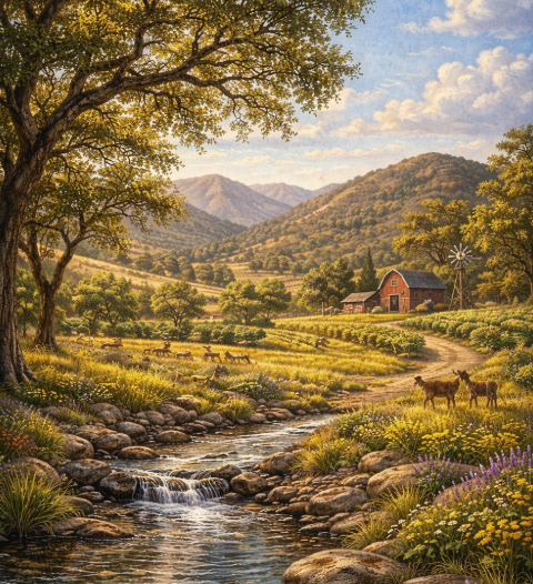
Long before ranchers and homesteaders arrived in what we now call Jamul, California, this land was known as a haven in the hills. Rolling valleys. Seasonal creeks. Oak-lined canyons. Hidden springs. Deep aquifers quietly replenished by winter rains.
For thousands of years, the Kumeyaay people thrived here, building a life rooted in community, sacred tradition, and the natural abundance of what they called Ha-mool — sweet water.
Today, Jamul remains one of the most distinctive rural communities in East County San Diego, shaped by its topography, water systems, and enduring sense of place.
If you’ve ever wondered:
What does the name Jamul mean?
Who originally lived in Jamul, California?
Why is Jamul known for sweet water?
How did Jamul develop into the rural community it is today?
Why are wells and aquifers important in Jamul real estate?
This guide explores the deeper story.
What Does the Name Jamul Mean?
The name “Jamul” is derived from the Kumeyaay word Ha-mool, meaning “sweet water.” This name is not symbolic. It is geographic.
Jamul’s landscape contains natural springs, seasonal creeks, underground aquifers, hydrologically active basins, and rolling hills that collect rainfall. These water systems sustained Indigenous communities long before subdivisions, ranches, or roadways were established.
The sweet water was life. And it still defines the region.
The Kumeyaay People: Jamul’s First Stewards
Before Spanish explorers, before Mexican land grants, before American homesteaders, the Kumeyaay people lived throughout what is now San Diego County, including Jamul.
For thousands of years, they thrived in harmony with oak woodlands, seasonal waterways, native plants, wildlife corridors, and natural springs. Acorns from oak trees formed a dietary staple. Water sources supported settlement. The basin’s geography allowed for both seasonal migration and permanent community life.
Jamul was not wilderness to the Kumeyaay. It was homeland. Understanding this history deepens appreciation for the land’s sacred and ecological value.
Why Water Shaped Jamul’s Identity
Unlike coastal San Diego communities dependent on imported water systems, Jamul historically relied on its own hydrology.
Rolling hills and sheltered canyons collect seasonal rainfall. That rainfall feeds into creeks, natural basins, and underground aquifers. Over time, water seeps into deep reservoirs beneath the surface.
These naturally replenished aquifers remain essential today. Many Jamul properties rely on private wells, natural spring access, and groundwater systems. The water is part of the land’s character and part of its rural independence.
Jamul’s Unique Topography
Jamul is defined by elevation changes, ridgelines, and sweeping valley views. This terrain does more than create beauty. It channels rainfall, supports native plant ecosystems, creates natural drainage patterns, sustains underground water storage, provides firebreak diversity, and preserves wildlife corridors.
The hills are not incidental. They are functional. This geography shaped early settlement patterns and continues to influence land use decisions today.
From Indigenous Land to Ranching Territory
As European settlement expanded into Southern California, Jamul transitioned into ranching and agricultural use. Homesteaders and ranchers recognized the land’s hydrological advantages.
Small dams were constructed to collect water for livestock, crop irrigation, and orchard growth. The same water systems that sustained the Kumeyaay supported ranching viability. Agriculture became central to Jamul’s rural identity.
Even today, Jamul is known for equestrian properties, working ranches, small-scale farming, vineyards, and acreage estates. Water access has always determined agricultural success in East County.
The Role of Wells in Modern Jamul Real Estate
For current homeowners and buyers, wells remain a defining feature.
Do Jamul homes use wells?
Many rural properties rely on private wells rather than municipal water systems.
Are wells reliable in Jamul?
Reliability depends on aquifer depth, recharge rates, and well maintenance. Many properties benefit from long-established groundwater access.
Does well water impact property value?
In rural East County, well systems are standard and expected. However, well depth, production rates, and inspection reports matter during transactions.
Understanding Jamul’s hydrology is critical when evaluating land and property.
Why Jamul Remains Rural
Unlike suburban areas closer to central San Diego, Jamul has intentionally preserved its rural character. Large lot zoning, limited high-density development, and community advocacy have maintained open space, agricultural viability, scenic corridors, reduced traffic density, and wildlife habitat.
The community values land stewardship. That philosophy aligns with its Indigenous roots.
Sacred Tradition and Modern Community
Today, Jamul’s name remains a tribute to its Indigenous heritage. Before streets and subdivisions, this land was cherished for sweet water, community gathering, seasonal rhythms, and sacred connection to nature.
Modern Jamul continues to reflect those values through tight-knit community relationships, local events, agricultural preservation, and environmental awareness. The pace remains slower than urban San Diego and intentionally so.
Frequently Asked Questions About Living in Jamul, California
Is Jamul considered rural?
Yes. Jamul is an unincorporated community in East County San Diego known for acreage properties, open space, and rural zoning.
How far is Jamul from Downtown San Diego?
Approximately 25 miles east, depending on the route.
Why do people move to Jamul?
Residents seek privacy, land, scenic views, quiet living, equestrian opportunities, and a slower lifestyle.
Does Jamul have natural springs?
Yes. The region historically contains natural springs and groundwater aquifers.
Hydrology and Fire Awareness
In Southern California, land stewardship includes fire awareness. Jamul’s terrain influences vegetation growth patterns, water availability, brush management, and defensible space planning. Understanding how water and topography interact helps homeowners prepare responsibly. Fire safety, drainage planning, and environmental compliance all intersect with the land’s natural systems.
Agricultural Viability in Jamul
Jamul’s aquifers continue to support olive groves, vineyards, small farms, livestock operations, and orchard cultivation. The soil, combined with water access, creates opportunity for sustainable agriculture. Many East County buyers specifically seek Jamul for this reason. Agricultural zoning protects that possibility.
The Cultural Value of Place
Communities with deep history often carry a different atmosphere. Jamul feels layered. You sense generational continuity, pride of ownership, respect for land, and community memory. When a place carries thousands of years of habitation, its identity becomes embedded.
Jamul’s Rolling Hills and Modern Development
While development has occurred, large-scale urbanization has not overtaken the landscape. Instead, Jamul features custom estates, gated acreage properties, ranch-style homes, equestrian compounds, and scenic driveways. Many homes are positioned to maximize valley views and maintain privacy. The topography naturally discourages dense building.
Water, Wells, and Property Due Diligence
For buyers considering Jamul real estate, water due diligence includes well production testing, water quality reports, pump system inspection, storage tank evaluation, and septic system review. These elements are standard components of rural property transactions. Local expertise matters when navigating these inspections.
The Meaning Behind “Haven in the Hills”
Jamul is often described as a haven in the hills. That description stems from natural protection offered by terrain, quiet living removed from highway corridors, community cohesion, and scenic isolation. Even with modern conveniences nearby, Jamul retains a feeling of retreat.
Wildlife and Native Plant Flourishing
The hydrology and topography also support biodiversity. Common features include oak woodlands, native grasses, seasonal wildflowers, migratory bird pathways, mule deer, and native wildlife. Preserving these ecosystems aligns with Jamul’s cultural heritage.
Why Jamul’s Story Matters Today
In an era of rapid development, understanding origin stories matters. Jamul is not simply a real estate market. It is Indigenous land, agricultural territory, a hydrological basin, and a preserved rural community. The name itself reminds residents and visitors of that sweet water legacy.
Jamul Real Estate and Long-Term Value
Properties in Jamul often appeal to buyers seeking generational homes, multi-acre estates, long-term land ownership, privacy, and independence. The value proposition is not proximity to nightlife. It is connection to land. That connection tends to hold enduring appeal.
Preserving Identity While Growing Thoughtfully
As East County continues evolving, thoughtful growth remains essential. Balancing property rights, environmental stewardship, cultural heritage, and infrastructure planning requires collaboration between residents and local governance. Jamul’s past informs its future.
A Community Rooted in Sweet Water
The word Ha-mool — sweet water — captures more than hydrology. It represents sustenance. Connection. Life.
From Indigenous stewardship to ranching resilience to modern acreage living, Jamul remains defined by water, land, and community. Its rolling hills and underground aquifers quietly continue the cycle that sustained thousands of years of habitation.
Final Reflection: Ancient Roots, Enduring Future
Jamul is not simply another East County zip code. It is a place where topography shapes lifestyle, water shapes settlement, heritage shapes identity, and community shapes daily life.
From the Kumeyaay people to today’s homeowners, Jamul has always been a land of sweet water and enduring roots. Understanding that history deepens appreciation for the land we walk, build upon, and call home.
And it reminds us that before subdivisions and roadways, this was sacred ground — sustained by water, guided by tradition, and grounded in place.
Check out this article next
Uncovering Jamul’s Hidden WPA Landmark in Deerhorn Valley
The Forgotten Works Progress Administration Water Crossing That Still Stands TodayNestled deep in Deerhorn Valley, just east of Jamul, lies a nearly forgotten piece of…
Read Article